Wednesday 21 September 2016

Earthquakes are tremors which are produced by the passage of vibratory waves through the rocks of the earth. If you throw a stone in a pound of still water, a series of concentric waves are produced on the surface of water. These waves spread out in all directions from the point where the stone strikes the water. Similarly, any sudden disturbances in the earth’s crust may produce vibrations in the crust which travels in all directions from the point of disturbance.


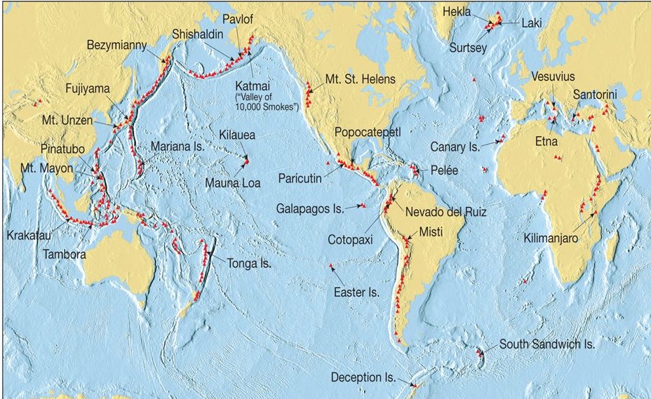
Earthquakes and volcanoes are endogenic forces while weathering and agents of sculpture are exogenic forces. Some are sudden forces and bring about sudden changes. Earthquakes and volcanoes are examples of sudden forces. There are other forces which work slowly and take longer duration of time to show their effects.
FOCUS AND EPICENTRE

The place of origin of an earthquake inside the earth is called its focus. The shock waves travel in all directions from the focus. On the earth’s surface, the shaking is strongest near the epicentre.


There are several types of earthquakes which affect different parts of the world at different times. Some of the common types of earthquakes are briefly described.
Tectonic Earthquakes- There are the most common earthquakes and generated by sliding of rocks along a fault plane.

Volcanic Earthquakes- As the name indicates these earthquakes are caused by volcanic eruptions and are quite devastating. However, these are confined to areas of active volcanoes.
Collapse Earthquakes- In areas of intense mining activity, often the roofs of underground mines collapse and minor tremors take place. These are called collapse earthquakes.
Explosion Earthquakes- When a chemical or nuclear explosion takes place, ground shaking occurs and an earthquake is known as explosion earthquakes.
Reservoir induced Earthquakes- Such earthquakes are caused by the pressure of water collection in large reservoir. The koyna earthquake was cause by koyna reservoir.
Measuring Earthquakes- The earthquakes are measured in terms of their magnitude and intensity. The earthquakes magnitude is related to the energy released during the quake and is recorded by an instruments called Seismograph. It is measured on Richter scale. This scale was developed by Charles Francis Richter. The magnitude is expressed in absolute numbers, 0-10. 
EFFECTS OF EARTHQUAKES

Earthquakes cause heavy loss to life and property. The maximum damage is caused near the epicenter of the earthquake. Its tremors were felt all over the subcontinent including India, Pakistan and Nepal. It measured 7.9 on the Richter scale. About one lakes people lost their lives. Sometimes earthquakes disturb the existing rocks strata and block the flow of Water River. The river water submerges the surrounding low-lying areas causing severe floods. The floods in the caused by an earthquake. Earthquakes occurring in sea, result in high waves in the sea water and cause heavy damage to ships. Such seismic sea waves are called Tsunamis in Japanese. Tsunamis which hit 11 countries. It was caused by a severe earthquake measuring 8.9 on the Richter scale and occurring of the coast of Sumatra (Indonesia).


Faults, thrusts and folds are often associated with earthquakes. An earthquakes disrupted several country roads on the floor of a broad valley in Japan during the earthquake of 1891. A tremendous fault occurred during the California earthquake of 1906, running for hundreds of kilometers along the coast. Earthquakes are responsible for land-slides in mountainous areas which causes heavy damage.

SEISMOGRAPH   

The science of earthquakes is known as seismology and the instruments which records earthquakes waves is called seismograph. The seismograph is a very sensitive instrument which can record earthquakes which occur thousands of kilometers away. It can also records vibrations so feable which are not usually felts by human sense. The construction of a seismograph is based on the principle of inertia—the tendency of any mass to resist a change in a state of rest or of uniform motion in a straight line is greater, the greater the mass of the object. It consists of a heavy solid object suspended from a vertical stand with the help of wire. Boom is used to keep it horizontal and stop its vertical motion. The heavy object is fitted with a mirror which receives an intensely bright ray of light which is reflected from it and falls on a revolving drum. A film is attached to the drum. If there is no earthquake the reflected rays of light make a straight line. When there is an earthquake, the rays make a zigzags line.


 The vertical stand is fixed on the base rock deep into the earth. The record of earthquakes waves by a seismograph indicates that three conspicuous pulses known as P, S and L-waves can be picked up. The first to arrive at the recording station are the primary or p-waves. These minutes. After this, a second burst of activity sets in with the arrival of secondary or S-waves. These have somewhat longer amplitude then the P-waves.


DISTRIBUTION OF EARTHQUAKES


The distribution of earthquakes is more or less similarly to that of volcanoes. The earthquakes mostly occur in weak crustal areas of the earth.
Circum-Pacific Belt. About 68% of world’s earthquakes are observed along the coasts of vast Pacific Ocean. This is known as the ‘ring of fire’. This is the area of intense volcanic activity also. This areas is closely linked with the region of crustal dislocations and volcanic phenomenon. Chile, California, Alaska, Japan, Philippines, New Zealand and the mid-ocean areas have had many minor and major earthquakes in this belt. Mountains here run along the border of continents and nearly parallel to the depressions in oceans. It causes sharpest break in relief which becomes a cause for the earthquakes.
Mid-world Mountain Belt. Nearly 21% of world’s earthquakes occur in the mid-world mountain belt. It extends parallel to the equator from Mexico across. Atlantic oceans, the Mediterranean Sea, from Alpin-ecaucasus ranges to the Caspian, Himalayan Mountains and the adjoining lands. This zones has folded Mountains, large depressions and active volcanoes.
Minor Belts. This remaining 11% of the shocks are recorded outside these two belts. Only a few occur along the fracture in Africa lakes, Red and Dead Sea zone.

FLOODS


Floods is a state of high water level along a river channels or on coast that leads to inundation of land. Floods are caused by excessive rainfall by the monsoons, tropical cyclones in the pre post monsoon periods, melting of ice and snow, storm surge silting of the river beds, changes in the river courses and deforestation. Floods occur commonly when water in the form of surface run-off exceeds the carrying capacity of the river channels and streams and flows into the neighboring low-lying flood plains. At times, this even goes beyond the capacity of lakes and other inland water bodies in which they flow. Flood is a natural hazard and it becomes a disaster when it inflicts heavy losses to life and property. Apart from natural forces such as heavy rainfall, snow melt, cyclones etc. unwanted human activities have played their own part in the genesis as well as spread of floods. Some such activates are indiscriminate deforestation, unscientific agricultural practices, disturbances along the natural drainage channels and colonization of flood-plain and river-beds.  

VOLCANOES

A volcanoes is a sudden and abrupt explosion in the crust of the earth through which magma, gas, smoke and solid material is ejected. The hot molten magma below the earth’s surface is brought to the surface as lava. Lava is a very high temperature, varying from 800 to 1300 Celsius and contains steam and several other gases. All these materials are ejection at greater pressure through a pipe which as it’s ‘Vent’ or ‘Neck’.
The lava forms a cone-like feature on the surface of the earth which is known as ‘Volcanic Cone’. The top of the cone has funnel-shaped or saucer-shaped depression which is known as the crater. The diameter of the crater may from a few meter to a few kilometres. Sometimes lava comes to the surface through joints on the sides of main cone and forms secondary cones.


The three types of materials including gases, liquids, and solids are ejection at the time of a volcanic eruption.
Gases. The gaseous substances are mainly composed of stream, products being hydrochloric acid, ammonium chloride, sulphur dioxide, hydrogen sulphide, hydrogen and carbon dioxide. Water vapour is the most important of all the gases as it accounts for 60% to 90% of all the gases thrown out by a volcano. This water vapour causes heavy rainfall after condensation in the atmosphere.
Liquids. The liquid matter is the lava. The temperature of freshly ejected lava may range between (600 to 1200) Celsius. Water also comes out along with lava. The speed of lava flow depends upon its composition, mobility and the slope of the ground. Usually the movements is very slow and even a speed of 15 km per hour is rarely achieved. But sometimes the speed may be as high as 80 km per hour.
Solids. The lava in the vertical passage gets solidified. The next volcanic eruption through the pipe is accompanied by explosion of highly compressed gases throwing out block of solidified lava from inside the choked pipe. The solid material consists of fine ash and dust particles and angular fragments mostly of lava rock blow up from within the vent. If the diameter of the solid block thrown out by a volcano is more than 33 mm. it is known as volcanic bomb or blocks. At places volcanic bombs weighing 60 tons have seen but their number is small.  

TYPE OF VOLCANOES


The three types of volcanoes are-

Active volcanoes. These volcanoes keep on ejecting volcanic material at frequent intervals. The Etna volcano of Italy has been active for the last 2500 years. The Stromboli volcano of Sicily Island explodes after every 15 minutes and is known as the Light house of the Mediterranean.

Dormant or sleeping Volcanoes. The dormant volcanoes are those in which eruption has not occurred regularly for a long time. But they cause great damage to life and property when they suddenly becomes active after remaining dormant for a sufficiently long time. Visuvius volcano of Italy has exploded only 10 times in about 1500 years. 

Extinct or Dead Volcanoes. The vent of an extinct volcano is blocked and its crater is filled with rain water to form a crater lake. Vegetation starts growing on it. The possibility of future explosion becomes remote. Many time an extinct volcano suddenly becomes active. This has happened in case of Krakatoa volcano. The Island of Krakatoa is situated in the Sunda Strait between the Island of Java and Sumatra. Its eruption in the year 1883 blew off the top of the mountain by an explosion which caused tidal waves about 16 meters high, killing 36000 people in west java. The sound of explosion was heard as far as Istambul (Turkey) in the west and Tokyo in the east. The volcanic dust and gases encircling the globe in the atmosphere caused strange sunrise and sunset conditions for about three years. Today Krakatoa is only a low Island with a lake inside its crater.

VOLCANIC LANDFORMS Materials ejecting out from a volcano create a variety of land-forms.


Ash or Cinder Cone. The volcanic material thrown out by volcano cools down quickly in small solid pieces known as cinders. The solid particles are rained down and form a circular cone around the crater. This cone is called cinder cone. The cinder cone is formed after a number of explosions. The average height of a cinder cone is about 300 meters and its side have concave slope. They are termed as central type of volcanoes because eruption takes place through a central hole in the crust connected with the interior through a vertical pipe. 

Acid Lava Cone or Dome. This cone is formed by acid lava which is viscous and has the dominance of Silica. The lava deposits itself near the neck immediately after explosion and form a dome after solidification Lessen Peak in California and Pary-de-done in France are some of the outstanding examples of doms.

Basic Lava Cone or Lava Shield. Sometimes, the basaltic lava having low silica content flows out quietly and gives rise to the formation of a shield. The lava flows out quietly around a central opening. In course of time, it builds up a shield-shaped volcano with a wide base and low slope. It cools as thin horizontal sheets. Probably the best examples are the Mauna Lao shield volcanoes of the Hawaiian Islands.

Composite Cone. These are probably the largest and highest volcanic cones. They are formed by lava ash etc. which are deposited one after the other in almost parallel layers. Sometimes the main cone is covered by a number of smaller cones.
Caldera. Caldera is a large roughly circular volcanic depressions often several hundred square kilometre's in area. Caldera usually has a number of smaller vents and can also contain a large crater lake. The distinction between craters and calderas is essentially one of size, one to kilometres being the lower limit for the diameter of a caldera. Calderas are formed in a variety of ways, but most accepted mechanism is the collapse or subsidence which may relate to explosive eruptions. There are numerous ex of caldera in Alaska and Aleutian Islands.


VOLCANIC PLUG. Volcanic plug is formed by the solidification of lava in the vent of the volcano after eruption is over. The plug becomes clearly visible after the erosion of the upper rock material. Such volcanic plugs are found in large number in the Hawaiian Islands. Sometimes it is called volcanic neck also. It can have 300 to 600 meter radius. The Devil Tower in Wyoming is the best ex of a volcanic neck.

Thursday 15 September 2016

DISTRIBUTION OF VOLCANOES    
A reveals that the volcanoes of the world are distributed in a specific manner. Most of the volcanoes are near the sea coast or on the Island because there are greater possibilities of percolation of water in these

 areas. The second important area of volcanic activity is that of new fold mountains. The mountain-building forces have left a very thin and weak crust in areas of folding and faulting. The total comes to 522 if the more ancient known eruptions are taken into account.
Borders of the Pacific Oceans. This is the most outstanding volcanic belt of the world in which 403 active volcanoes are found. This known as the ring of fire. On the east coast of the Pacific Ocean, this belt extends from Cape Horn of South America to Alaska in North America. Along the western coast of the Pacific, this belt extends to Kurile Islands, Japan and Philippines Islands.
Mid-world Belt. This is also known as Alpine-Himalayan belt. It starts from Madeira and Canary Islands and crosses the Mediterranean Sea beyond which it runs along the Alps and Himalayan ranges. After crossing the Himalayans, this belt crosses yunan, Myanmar, Andaman and ends in Indonesian Islands.
Other Areas. Some volcanoes are situated in the mid-Atlantic where Cape Verde is very famous. Azores, St. Helena and Ascension are volcanic islands but 20 very active volcanoes. Comoro, Mauritius and Reunion are important volcanoes near Madagascar in the Indian Ocean. Some active volcanoes such as Arelus and Terror are found close to Antarctica.         

E arthquakes are tremors which are produced by the passage of vibratory waves through the rocks of the earth. If you throw a stone in a po...